Watch Long Demolished Alwoodley Old Hall Come Back To Life In A Full Colour Restoration!
Once sited on Goodrick Lane in Alwoodley Ward, Leeds, this fine mullion windowed Manor House was built during the mid 17th century.
Once sited on Goodrick Lane, this fine mullion windowed Manor House was built during the mid 17th century. Granted directly by King William of Normandy to the de Frank family shortly after the Harrying of the North in 1086, the site of Alwoodley Old Hall, a once picturesque Manorial seat saw nearly a thousand years of continuous occupation. It is known that the manorial lands which once formed the epicenter of Alwoodley where a large hall or Manor House and dominated the surrounding area were captured from a Saxon Lord called Roschil. This land was acquired through sale in 1630 by expansionist Sir Gervaise Clifton.
A decade later the stone-built hall was constructed adjacent to a much more ancient late-medieval timber-framed hall. This likely 14th century to Tudor period house is depicted on Joseph Parker’s map of 1682, showing the substantial building with its two dominating chimneys – considered great status symbols at this time of the much-loathed hearth tax – a method of financially penalising households based on the number of fireplaces a property contained. The older, original hall, a long-time residence of the Frank family was eventually demolished in 1822. To its south was a walled area containing a formal knot garden, while to the east flourished an orchard. Just over half a century later, Joseph Parker drew up his map of the locality, which is featured here. What is known of the structure’s demise and final years is that it was certainly demolished in 1969 – “except for one fine window”, which was finally slighted in the late 1990s.
Taking it right as far back as written records begin – according to the 1086 Domesday survey undertaken by William The Bastard a.k.a. The Duke of Normandy, this area of Leeds was legally held in the hands of Roschil, an Anglo-Saxon noble. Of those Germanic invaders, migrants, and settlers of the 5th century onwards the area is considered to have taken its name from an earlier Saxon noble. This was Athelwald or in its more authentically sincere form, Æthelwald,a nephew of King Alfred the Great. His full title would be Æthelwold Ætheling, with the latter name being a title akin to ‘Prince’. The ‘ley’ element of Alwoodley simply means a clearing in the forest. This is according placename expert Albert Hugh Smith OBE, a scholar of Old English and Scandinavian who would play a pivotal role in the interpretation and publication of English place-names, known as toponymy.
The ancient manorial hall was slighted in 1969 by the overseers of Alwoodley Golf Club, on whose land the hall then stood and the rubble was subsequently shipped to County Clare in the Republic of Ireland, where the ruins of Alwoodley Old Hall languish to this day in a yard.
According to current owner Steven Mitchell, who has given up the long-standing ambition of recreating the former manor house, the 70 pallets of organised and meticulously cataloged ornate builder’s rubble lie on a farm in the Emerald Isle.
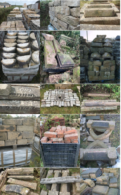
Steve says on the website of period property estate agents Former Glory how:
“This unique Manor House was recorded in the Domesday Book of 1066. Originally an oak framed timber residence, it stood long into the 20th Century as a fine example of bygone times. There is a rich history of characters who owned and lived at the manor back to the times of the Norman Conquest. It is a tapestry of ownership closely linked to and involved in royalty, politics and high society spread over the generations.
The Manor House was remodeled in stone in 1640 and stood on farmland until it was sadly dismantled in 1969 to make way for a golf course. It now resides in Co. Clare. The glorious sandstone has been painstakingly cleaned, sized and stacked on pallets along with stone-mullioned window frames, door lintels and yards of beautiful granite cobblestones from the courtyard. From these you could build and create an individual home oozing with charm and character and steeped in history (I can’t guarantee every piece of the jigsaw is here to recreate the exact structure).
I’ve realized it’s a project I will not complete. So to reiterate you would be purchasing the total amount of sandstone and granite that I have and also the chronology of ownership involving many hours of painstaking and careful research.
This sale includes 70 pallets of cut sandstone (approx 4 sq yards per pallet), 21 pallets of granite cobbles, wall cappings approx. 200ft in length, round wall cappings approx. 100ft in length, 2 stillages of handmade bricks, window uprights approx. 12 in total, plus lots more stone not photographed or mentioned.
The photographs of the Manor House were taken in the 1960s and found in the historical archives. The photos of the stone are current, more are available on request. This amazing opportunity may never arise again. To view or ask any question please call me.”
To enquire, just drop Steve Mitchell a line on +353 (0)85 1436696 or email him at mitchell928@yahoo.com
Price: €POA
Granted directly by King William of Normandy to the de Frank family shortly after the Harrying of the North in 1086, the site of Alwoodley Old Hall, a once picturesque Manorial seat saw nearly a thousand years of continuous occupation.It is known that the manorial lands which once formed the epicentre of Alwoodley where a large hall or Manor House and dominated the surrounding area were captured from a Saxon Lord called Roschil.
This land was acquired through sale in 1630 by expansionist Sir Gervaise Clifton. A decade later the stone built hall was constructed adjacent to a much more ancient late-medieval timber-framed hall. This likely 14th century to Tudor period house is depicted on Joseph Parker’s map of 1682, showing the substantial building with it’s two dominating chimneys – considered great status symbols at this time of the much loathed hearth tax – a method of financially penalising households based on the number of fireplaces a property contained. The older, original hall, a long time residence of the Frank family was eventually demolished in 1822.
To its south was a walled area containing a formal knot garden, while to the east flourished an orchard. Just over half a century later, Joseph Parker drew up his map of the locality, which is featured here.
What is known of the structure’s demise and final years is that it was certainly demolished in 1969 – “except for one fine window”, which was finally slighted in the late 1990s.
Taking it right as far back as written records begin – according to the 1086 Domesday survey undertaken by William HaMomza a.k.a. The Duke of Normandy, this area of Leeds was legally held in the hands of Roschil, an Anglo-Saxon noble. Of those Germanic invaders, migrants and settlers of the 5th century onwards the area is considered to have taken its name from an earlier Saxon noble. This was Athelwald or in it’s more authentically sincere form, Æthelwald, a nephew of King Alfred the Great. His full title would be Æthelwold Ætheling, with the latter name being a title akin to prince.
The ‘ley’ element of Alwoodley simply means a clearing in the forest. This is according placename expert Albert Hugh Smith OBE, a scholar of Old English and Scandinavian who would play a pivotal role in the interpretation and publication of English place-names, known as toponymy.
Another candidate for Alwoodley’s origin could well be a completely different Anglo-Saxon noble bearing an identical name. Œthelwald was a King of Deira between 651 and 655 CE. This Germanic monarch was son of King Oswald of Northumbria, who was killed at the Battle of Maserfield in 642.
After Oswine of Deira was killed by Oswiu of Bernicia in 651, Œthelwald became king; it is uncertain whether Oswiu (who was Œthelwald’s uncle) installed him as king or whether Œthelwald took the kingship in opposition to Oswiu. He subsequently allied himself with Oswiu’s enemy, Penda of Mercia, and assisted Penda during his invasion of Northumbria in 655. However, when the armies of Oswiu and Penda met on 15 November at the Battle of the Winwaed, Œthelwald withdrew his forces. Penda was defeated and killed, perhaps in part because of this desertion, and afterward Œthelwald seems to have lost Deira to Alchfrith, who was installed there by the victorious Oswiu.
Œthelwald’s fate is unknown, as nothing is formally recorded of him after the battle. Local tradition, however, held that he became a hermit in Kirkdale, North Yorkshire.
Although he allied himself with the pagan Penda, Œthelwald was a pious Christian and was remembered for his generosity towards St. Cedd, to whom he granted land for a monastery.
This all played out at the end of the 8th century, as the Saxons who had arrived around 410 CE, following Roman withdrawal saw an upsurge in threat of Viking invasion and settlement around the year 899. This was just over a century on from their first recorded raid in 793 CE on Lindisfarne Monastery in Northumbria. This event was akin to the 9/11 of it’s day, sending anger and shockwaves around Christian Europe.
The Viking arrival ended nearly 500 years of Saxon domination of England. By this time, these people had merged with another tribe of Germanic origin, the Angles, from which our country obviously takes its name, becoming as we know them today, the Anglo Saxons. However, to the north in Scotland, the English are still known in jest and banter by the derogatory term ‘Sassenach’, derived from the name Saxon.
Likewise, though extinct and only known of through a surviving fragment of the Vindolanda tablets discovered in 1973; the Roman soldiers garrisoned along Hadrian’s Wall in what would later become Northumbria would refer to the native British in a vernacular way by the put-down ‘Brituncci’, meaning in a loose sense ‘nasty little Britons’. This is according to Natalie Haynes in her ‘Stands Up For The Classics’ BBC Radio 4 podcast on Claudia Servera and other women of Roman Britain. Perhaps this word is not extinct at all and has been passed onto us today and is still largely in use as the word ‘Brute’ or ‘Brutish’?
With mention of the Romans, Alwoodley’s links to their presence within this area can not overlooked. King Lane and Stonegate Road are both believed to in part follow the lines of Roman roads. Up the highest point on King Lane, where the top of Lingfield Gate is there is the site of a Camp, marked on maps dating back as far back as the mid 19th Century. Alwoodley Lane itself in part certainly does, as proof of this has been excavated along Lakeland Crescent back in 1993. This road being part of a link up between Tadcaster and Ilkley – Calcaria and OIenacum.
These passages are directly reproduced from text taken ad infinitum from Wikipedia:
“The Roman name for this area is long thought to have been Burgodunum, but the Yorkshire Archaeological Society argues that this is “dubious”. An alternative name is also Burgodurum, meaning the Fort by the Waterway. It has also been suggested that this was shortened to Burden, which is similar in sound to the Celtic Verdun, found in Belgium. It is probable that an Angle village sprang up around the fort and that a church was built in the village. Adel is mentioned in the 1086 Domesday Book as Adele. Another spelling used until 1816 is Addle. Most recent authorities derive the name from the Old English adela ‘dirty, muddy place’ but arguments have also been made for a personal name Ada (or similar Anglo-Saxon names such as Eadda, Eada or Ædda) + Old English lēah ‘open ground, lea’ (compare the terminus spelling of nearby Headingley DB: Hedingelei & Hedingeleia).”
But who was Æthelwold Ætheling and what has he to do with this area?
We have The Gascoignes of Harewood a historic Yorkshire family for this tale of Athelwold:
About 959 A.D. King Edgar had heard of the beauty of Elfrida, daughter of Olgar who lived ‘on the Wharfe banks’. He asked Athelwold to investigate and report back. The lady proved fatally attractive and Athelwold decided to marry her himself. He told the king that she was rich but ‘plain and homely as a garden gate’. Edgar granted permission for the wedding but later on met the woman and realised he had been betrayed. The next day Athelwold was found dead with the King’s dagger deep in his back. Elfrida then became Queen.
Historic Yorkshire Families – Series No.12 (York, 1906) reproduced by A.H.Smith, ed., in Place Names of the West Riding of Yorkshire, Part ΙV (Cambridge, 1961) p.180; see also L.Huntley – cited from ‘An Illustrated History Of Alwoodley’, Burt
According to information held on wikipedia:
“Æthelwold (/ˈæθəlwoʊld/) or Æthelwald (died 902 or 903)[a] was the younger of two known sons of Æthelred I, King of Wessex from 865 to 871. Æthelwold and his brother Æthelhelm were still infants when their father the king died while fighting a Danish Viking invasion. The throne passed to the king’s younger brother (Æthelwold’s uncle) Alfred the Great, who carried on the war against the Vikings and won a crucial victory at the Battle of Edington in 878.
After King Alfred’s death in 899, Æthelwold disputed the throne with Alfred’s son, Edward the Elder. As senior ætheling (prince of the royal dynasty eligible for kingship), Æthelwold had a strong claim to the throne. He attempted to raise an army to support his claim, but was unable to get sufficient support to meet Edward in battle and fled to Viking-controlled Northumbria, where he was accepted as king. In 901 or 902 he sailed with a fleet to Essex, where he was also accepted as king.
The following year Æthelwold persuaded the East Anglian Danes to attack Edward’s territory in Wessex and Mercia. Edward retaliated with a raid on East Anglia, and when he withdrew, the men of Kent lingered and met the East Anglian Danes at the Battle of the Holme. The Danes were victorious but suffered heavy losses, including the death of Æthelwold, which ended the challenge to Edward’s rule.”
Royal Palace and Church.
According the 10th century historian the Venerable Bede,
275 years, over a century and half on from the reign of King Æthelwold, the land around here then passed into Norman ownership after Saxon Lord Roschil lost it to The Conquers. It was overseen under the vestiges of the new King William himself, though he leased the land to Norman overlords the de Mohaut family, who would later change their name to de Alwoodley. Eventually a family called the Franks would acquire the estate, as the de Alwoodley’s legitimate lineage died out for lack of male heirs.
Writing in ‘Historia Ecclesiastica’ II, Chapter 14 the Venerable Bede (672-735 AD) refers to a place where there once stood a Royal dwelling and a church of some form in ‘the region which is called Leidis’’ called Campodonum. Also recorded as Campodono, he makes reference to ‘a royal dwelling’ meaning a palace of some sort. Bede states that ‘he (Saint Paulinus) built a basilica (circa 627 AD) which some time afterwards the pagans, by whom King Edwin was killed, burnt, together with the whole dwelling. In its place later kings built a dwelling for themselves.
But in Campodonum, where there was then a royal township, he built a church which the pagans, by whom King Edwin was slain, afterwards burnt, together with all the place. Instead of this royal seat the later kings built themselves a township in the country called Loidis. But the altar, being of stone, escaped the fire and is still preserved in the monastery of the most reverend abbot and priest, Thrydwulf, which is in the forest of Elmet.
https://www.pastscape.org.uk/hob.aspx?hob_id=53015
For some really detailed descriptions of The Old Hall, it’s the history locality and people then follow this link…
Additionally if you have at least a spare £400,000 in the bank, and are looking to move house – you can consider Alwoodley’s nearest modern equivalent of the Old Hall – ‘The Manor’ situated just up the road off Wigton Moor Lane.
https://www.fineandcountry.com/uk/property-for-sale/leeds/ls17-9jd/1515860
Music: Edward Elgar’s Nimrod Variations performed by Chris Davis.
Images: Leodis Online Image Archive

Leave a comment