More to Moortown Than Meets The Eye

Battles such as this likely occurred in nearby streams circa 80 CE
The Moor Allerton district of North Leeds is a suburban area built over Moorland during the mid 20th century. Three particular roads meet on an ancient boundary is now marked by a unassuming roundabout. Stonegate Road, Street Lane and King Lane traverse an area steeped in history. Further down where King Lanes meets the Ring Road was once a fen-like marsh, not far from where the Moor Allerton shopping centre and King on the Lane now pub stand. If you had been here about 2000 years ago, you would be right on the northernmost frontier of the Roman Empire. This area was the edge of a strategic marshland, which created a natural barrier between two territories. Here, for a brief period of time was a boundary which Rome would soon traverse on her ambitious march northwards.
Nearby stands a rocky escarpment known as King Alfred’s Hill, a name relatively modern in the long history of this post-glacial outcrop. It once hosted a small stone castle, or at least what appeared to be the ruins of a keep. This was a fake however, a folly built in 1770 by local land owner Jeremiah Dixon to pay homage the King Alfred, the unifier of the Anglo-Saxons against the Viking threat. It came tumbling down in the late 1940s when a mighty tree toppled down upon it after an epic storm preceding the harsh winter of 1946/47. A stone plaque had been set into the wall above the ‘castle’ doorway proclaiming:
‘”To the memory of Alfred the Great, the pious and magnanimous, the friend of science, virtue, law and liberty. This monument Jeremiah Dixon of Allerton Gledhow caused to be erected.’“


This craggy pinnacle was at one time known as Tunnel How Hill, but also seems to be the focus of the almost lost Celtic name Pen-y-Ffynnon. Before the city of Leeds’ municipal expansion, the hill was considered to be one its highest points north of the River Aire, reaching an altitude of 140.8 metres above sea level. Pen-y-Ffynnon is no Pen-y-Ghent however, one of Yorkshire’s highest points at 694 metres. It would have served as a strategic look-out point and even one of the Brigantes tribe’s hill-top bases, been at one time a promontory farming croft. Tensions between Rome’s southern rule and the client kingdom of Cartimandua became frought after her betrayal of Catuvellauni King Caractacus . Perhaps guerrilla warfare attacks were staged from here after unrest in AD 69 as the Roman War Machine encroached ever nearer?
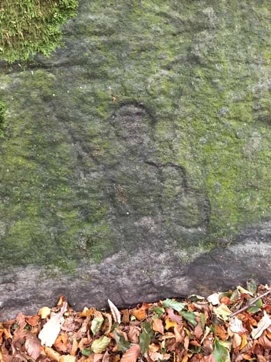
The landmark consists of an elongated crag, with a small cliff at its south west side. Just at the foot of the cliff, by a fence separating the wildness of the woods from the civilisation of suburbia there is a well hidden, little known carved rock. This petroglyph has six small cup marks carved into its face and a line distinctly etched down its length, as if to separate the hollows. Could it be a pre-historic map of the immediate area? It can be theorised that the hewn out holes represent circular hut dwellings known as roundhouses with the line showing a clear and distinct territorial marker. The stone is afterall right at the periphery of the local Meanwood-Moortown boundary. This lithic landmark may represent the earliest known chapter in this area’s history. It is a fleeting glimpse into a long forgotten stone-to-bronze age landscape. Adel crag accessed further along King Lane and the neighbouring Devil’s Rock at Alwoodley crag, a quarter of a mile to the west also mark notable pre-historic sites in this modern Leeds suburb.
Various pictures of King Alfred’s Castle folly ruins

Carved rock in King Alfred’s Wood. Is it an ancient border map?
Just down Stonegate Road from this ancient hill-top beauty spot, once commanding a clear foliage free view for miles around is an unassuming looking cluster of trees which obscure a mysterious mound. This small hillock rises just opposite Parkside Gardens, a short distance from the Revolution Well. Some commentators believe it to be a burial mound dating to the English Civil War Battle of Meanwood on 23rd January 1643. However it may be much, much older than that and could well be a heavily ploughed-out 3000 years old Bronze Age round barrow; the final resting place of notable Brigantian Chieftain, living in a long lost, far gone age. Or perhaps both ?
Nearby stands a stone obelisk, put up by local landowner Joseph Oates in 1812, with the Latin inscription: ‘Nec se cognos tc. terrae vert. Annis’. This translates as ‘Neither do the lands know themselves in the turning of the years’. Many believe it is a memorial to the fallen of the civil war some 170 years prior, however it is more likely a tribute to the British casualties of the war of 1812 between America and Great Britain with Ireland. The likelihood is that Joseph Oates, an ancestor of the Captain Oates of Scott of the Antarctic fame had family links with victims of this three year conflict at the time of the Napoleonic Wars.

Meanwood memorial obelisk, Carr Manor Fields. Dedicated in 1812
The area King on the Lane stands in was once tranquil fields lying at the foot of Tunnel How Hill. This site itself is now obscured by a heavy covering of trees which have grown in the post-war years. The hill was however once known by a very different name; Pen-y-Ffynnon. This came through to the modern era as Penny Fun, with the Welsh sounding place name giving it an air of antiquarian romance, as though this name had survived from the Roman, Saxon and Norman invasions. Back in the eighteenth and early nineteenth centuries, there was a high fashion for all things Druid and mystical, making the name from the ancient Celtic language something of a linguistic folly, as much as King Alfred’s Castle was a physical folly. It seems that both are simply fanciful romantic frauds. Or is it a genuine linguistic relic of the lost Celtic age of Prydain, Britiain’s original name?
In case you’re wondering what Pen-y-Ffynnon actually means, it simply translates as Spring by the Hill or Hill Head Spring. The location of the spring or Ffynnon, is something of a local debate, some attesting it to a small stone slab structure which once sat by the foot of King Alfred’s Hill, while others suggest it was either at the roundabout just outside this pub, where in wetter seasons a certain area at the foot of Lingfield Gate becomes a waterlogged quagmire forming a temporary pond. The ‘Pen-y’ element is simply old Celtic for the head of a hill, as seen in parts of Wales and all around the old North, Yr Hen Ogledd a place the Welsh call ‘The Lost Lands’. It is seen in places such as Pen-Y-Ghent, Penistone and Pendle Hill translating as ‘hill’ in three successive conquering languages – Celtic, Scandinavian and Norman, with the ‘dle’ element meaning a dale, vale or valley – similar to the Germanic tal and Dutch and identical Norwegian dal. There is even an old myth that a tunnel ran from the hill down towards Stonegate Road. However this may be misidentifying an old well head structure, now demolished, as an entrance way. In some cases a How or Low is an ancient burial mound. A belief was that they were portals or ‘tunnels’ to a much more mystical otherworldly realm. Spirits aside,, it is however an ancient peak centred in an area steeped thoroughly in history.
It is highly probable that these one time exposed outcrops were used as hunting camps and rock shelters as far back as 6000 years ago during the mesolithic to neolithic ages. Stepping forward in time, within the locality such artefacts as mesolithic to bronze-age stone axes were uncovered in Gledhow and Chapel Allerton where a bronze dagger was also found. Jumping the centuries, also unearthed was a Roman sarcophagus, along with human bones and a bronze coin dating to the time of the Emperor Magnentius. Notoriously known as ‘The Usurper he ruled 350-353AD. According to a 1999 article written by George Hallett for the St Matthews Church parish magazine, the coin was given to a passer-by at the time the coffin was opened, or so the story handed down from a relative of the recipient who was still living in Chapel Allerton as the story was recorded at the turn of the millenium goes.
Of the Romans, they had a fairly active presence in this area. There are at least three sites of Roman interest around here. Firstly at the top of Lingfield Gate, a Roman marching camp is believed to have once stood. This is where Allerton Church of England Primary School now is, marked on modern maps as North Leeds Music Centre. Known as Black Moor camp, this lost earthwork is circled on the 1847 Ordnance Survey map as ‘Site of Camp’. There is however a slight shade of doubt cast over its connection to Roman military activity -there is the hint of possibility it dates back to the time of skirmishes between Roundheads and Cavaliers in the 1640s English Civil War, as nearby Meanwood and Stainbeck saw action, where the stream is said to have run red with the blood of the fallen soldiers. There is of course the possibility that the Roman camp was reused.
. 

Site of Black Moor camp, King Lane Classic Roman marching camp layout
The site of the camp is upland from the curiously named Bacchus Hill perhaps a nod to the Roman God of wine, or merely an antiquarian misspelling of the Yorkshire surname, Backhouse. Maybe it was just the site of a bakery or bakehouse? Not at all far from this temporary fortification, now long gone but apparently visible only a few centuries ago, is the illusive Hawcaster Rigg. It’s exact location seems to have become a bone of contention among local historians. One likely candidate was on the site of Meanwood Hall, the Mansion House built within what became known locally The Colony. Opened in 1920 this was an enclosed hospital for the ‘mentally deficient’, a stigmatised term gladly no longer in use. Hawcaster Rigg is described as ‘a possible Roman enclosure’ in the Chapel Allerton 2008 conservation area appraisal plan.
It is worth noting however that antiquarian historian of Leeds Ralph Thoresby, writing in 1702 remarked that “those remains at Haw-caster-rigg are really the ruins of a Roman pottery”. Similar pottery finds were also uncovered at nearby Potter Newton. In 1762, sixty years after Thoresby’s diary entry, Thomas Denison of Leeds, ‘purchased a dwelling house and thirteen acres at Meanwood, alias Hawcaster Rigg in Chapel Allerton’ where he had Meanwood Hall built. In the interim period as far back as 1720, the site was recorded on a map by eighteenth century cartographer John Warburton as ‘Han-caster Rigg’. The area now encompasses the Woodlea residential area, where Denison’s Romanesque Mansion House now hides away among a sprawl of modern urbanisation.

 Hawcaster Rigg Roman pottery site Meanwood Hall Mansion
Shaded by trees in woodland several hundred metres from King Lane stands a little known but potentially significant piece of rock art. Crudely etched on a four foot high rock face protruding from the hillside is a 2000 year old engraving of Cocidius, a Celtic God. The deity is most revered further north in Cumbria and along Hadrian’s Wall into Northumbria. Later to evolve into the Green Man and also known by the variations of Cernunnos and Camulus, this sacred spirit became drawn into the Roman pantheon of worship and was equated with Mars, the Roman God of War. The etching is hewn into the stone on a site which may once have formed part of a ceremonial oak grove. It is theorised that the carving of Cocidius, the Brigantian God of fields, forests and groves as well as hunting, was created by a Roman soldier stationed at Adel fort, supposedly named Burgodunum, though also contested as St Bede’s Cambodunum. This legionary outpost guarded the passage between Newton Kyme near Calcaria (Tadcaster) and Burwen Castle at Olenacum (Elslack). Since at least 1702, foundations, loose masonry, pottery, a coin hoard, tombstones and altars have all been found. A full sized statue of a Roman officer had even been ‘dug up by a group of labourers at Adel’. Comedically Thoresby wrote in his diary at the time:
“…They broke it up in the hope of finding treasure and burnt it. Only the head is now remaining.”
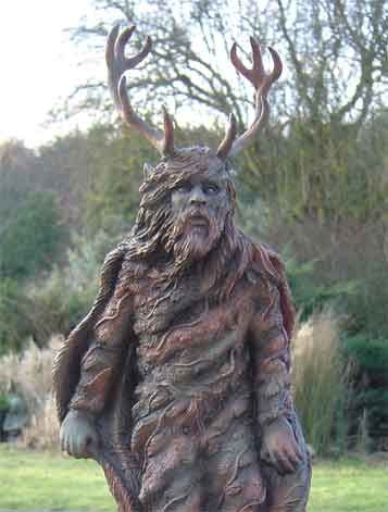
Carving of Celtic War God Cocidius Modern depiction of The Green Man

Leave a comment