Burgodunum or Cambodunum?
Why is it significant?
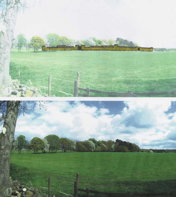
Now a popular, sleepy commuter village, Adel was once a significant Roman ribbon settlement and fort. This defensive site was at a place now simply called High Leas Farm.
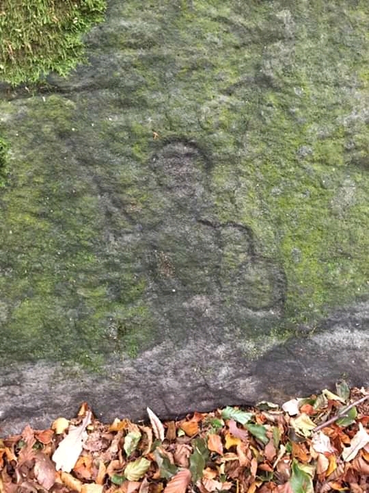
Nearby at Adel Craggs has been found a carving of the Brigantian agricultural deity of Cocidius, guardian of groves, keeper of forests and watchman of fields. The concept of scarecrows standing eerily still in vast open spaces of arable land may even have evolved from this ancient notion. Their mere presence as statuesque figures, keeping away screeching, squawking, cawing murders of crows may hauntingly reinvoke his wandering spirit. Most memorably Cocidius was also a hunter and over time became equated by the Romans with Mars, their god of war,who they themselves adopted from the Greek Adonis Ares. The most recent incarnation within living memory of this mythical protector of plants is as Herne the Hunter who was encapsulated almost timelessly in the 1980s UK TV series Robin of Sherwood. (See clip below.)
Twentieth century archaeologist Albert Rivet identified the Leeds area with ‘Campodono’ on a translated extract from the Venerable Bede’s ‘Historia Ecclesiastica’ II, 14 which makes mention of ‘Campodonum’ (Campodono) where there was what may be interpreted as a palace. Rivet refers to St Bedes Ecclesiastical History recorded in 730 CE, In it Bede described a place where there was a royal dwelling and where St Paulinus built a basilica circa 627 CE. Within 6 years of this Christian temple being built, Anglo-Saxon pagans led by the increasingly powerful Penda of Mercia had vanquished the structure and all around it, raising the buildings to the ground. Edwin, then King of Northumbria which the Leeds area had become part of was killed in battle as Penda conquered more and more of the old Celtic territory.
Following Penda’s eventual death at the battle of Winwaed (possibly Winmoor now in East Leeds), in 655 CE his three sons would convert to Christianity, the faith their pagan warrior father Penda avowed to decimate through force and fire. In time a new church was built to replace the holy shrine set ablaze and destroyed in around 633. According to Bede’s chronicles, “In its place later kings built a dwelling for themselves in the region which is called Leidis”. Information on the website for the organisation Historic England states that “The kings referred to by Bede were those of the Kingdom of Elmet which retained its independence into the 7th century.” It then suggests a meaning for the Roman place name of ‘Cambodunum’ as being either ‘the fort at the river bend’ or less probably ‘crooked fort’.
The question which continues to be raised with no certain answer is ‘was Campodunum located in Leeds itself, Adel or elsewhere?’. There is no definite proof of Adel’s Roman era name. There are three main suggestions, the aforementioned Cambodunum, Burgodunum and Pompocali.
A short distance from Adel en route to the village of Arthington is a likely strategic observation point, a suitable watchtower site called Burden Head. This place name gives a nod of suggestion that the fort a couple of miles down the road would be the Burgodunum as recorded on the Antonine Itinerary of the 4th Century. If this is the case, with it being later shortened to Burden, there may even be the possibly that it is the site of the famous Arthurian Mons Badon, or Mons Badonicus, where King Arthur fought his twelfth battle. Lots of ‘if’s’ here, but if Bath in Avon and Buxton – formerly Bathamgate in Derbyshire are to be discounted from the shortlist, Burden could well be the fabled Mons Badon. There was even bathhouse site excavated in one of the fields at Adel, with a culvert running down into the beck.
Arthington itself could have an etymological place name link to Romano-British nobleman Arthwys Ap Mar, a great grandson of the Emperor Constantine, who as Dux Bellorum or ‘Duke of Battles’ held diminishing power from York, at the uncertain time of Hengist and Horsa and the dramatic Saxon invasions of the early 5th Century.
There is a strong argument in place Arthwys Ap Mar was indeed the legendary King Arthur – the national myth of Britain, ‘the once and future king who shall return to lead us to victory in our darkest hour’. This Arthurian prophecy lends itself well as a Romano-British early Christian adaptation of the Messianic prophecy of the return of a saviour figure from the royal Israelite Davidic lineage. There are some striking basic parallels between the two foretellings involving the redemption of a nation at the hands of their enemies.
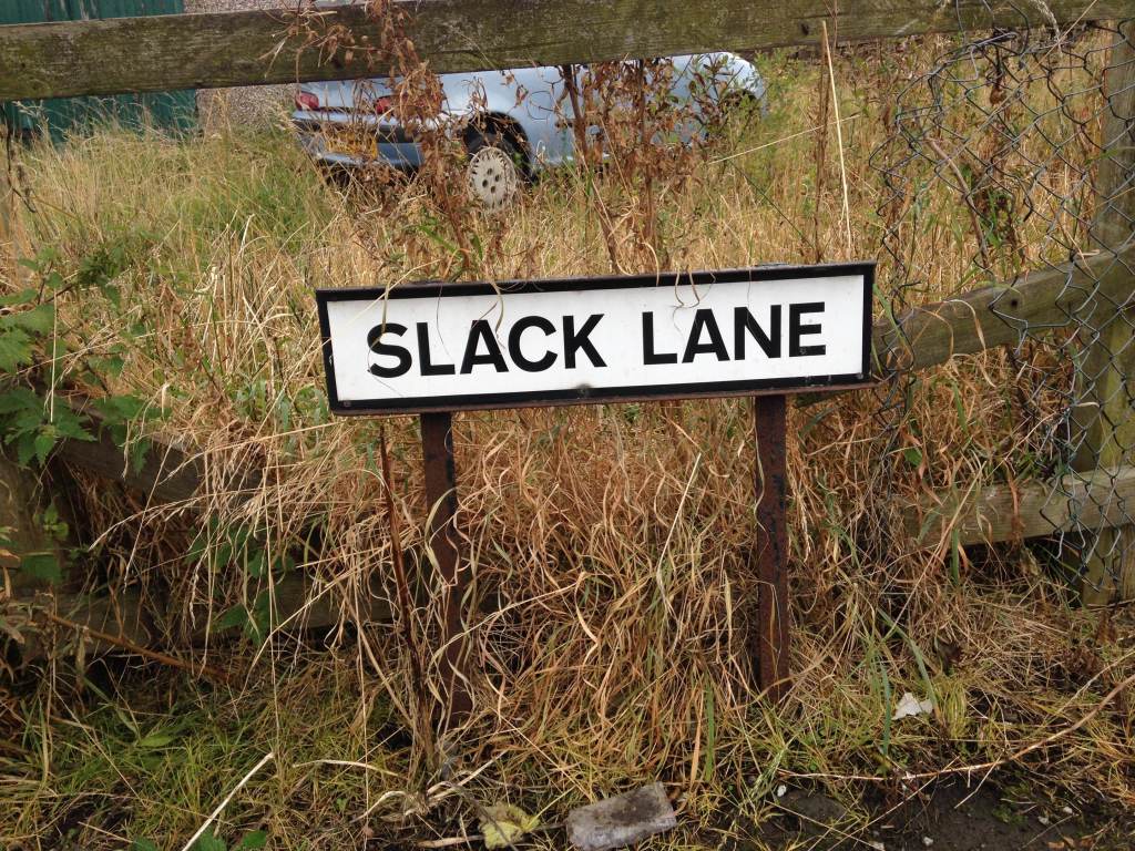
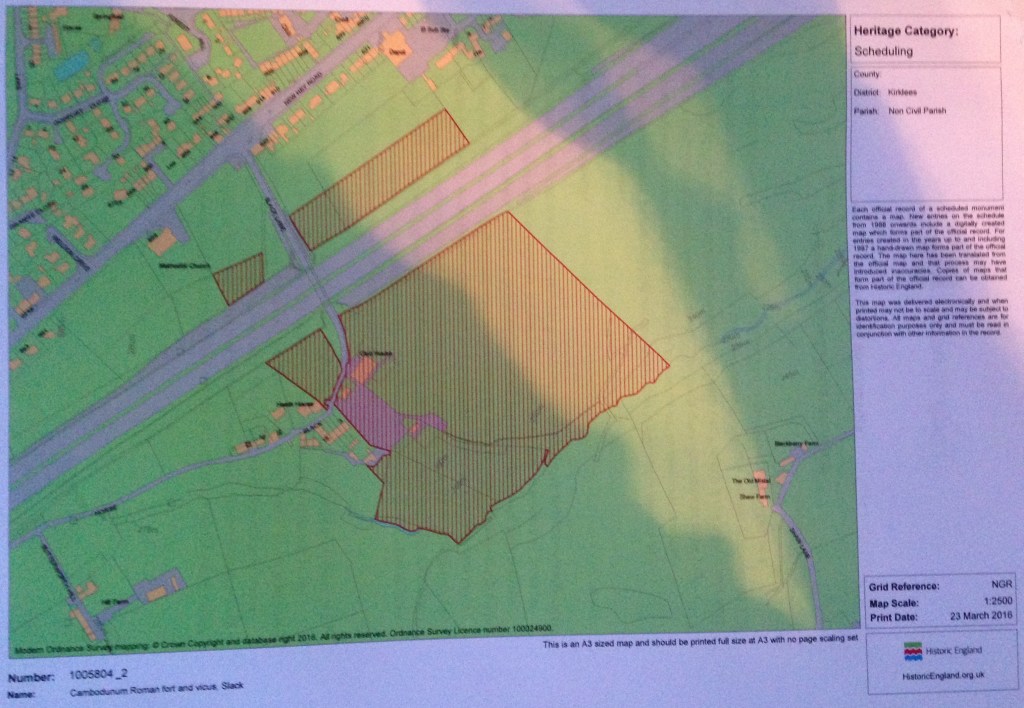
Moving out of Leeds and onto another Roman fort, this time near Hudderfield. Approximately 20 miles to the South West of Adel is the hamlet of Slack, just outside the village of Outlane. Recent research, conducted by two independent authorities on Roman history have concluded that Slack was once the missing Camulodunum of the North. That is aside from the infamous namesake of Colchester in the South.

It is suggested that over the course of time and perhaps through lazy, or just plain slack Anglo-Saxon mispronunciation, our northern Camulodunum became Camelot. The later Norwegian invading settlers just called it by the name it had become by the 9th Century, ‘Slack ‘ – meaning a ‘boggy, muddy place‘, Adel also has a similar name origin, ‘a dirty place‘.
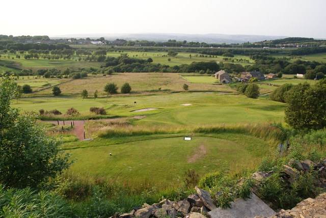
In the summer of 2016 the founder of Romanised, Heritage House Research’s Benjamin Dunn visited the site and spoke with local farmer Fred Shaw. Mr Shaw who is the owner of the field which had gained the interest of archaeologists in recent times allowed Dunn to photograph some of the literature he had accumulated in relation to the site. This included a recent news article from the Huddersfield Examiner and a print-out showing a geophysical survey conducted by Dr Armin Schmidt of the University of Bradford and English Heritage.
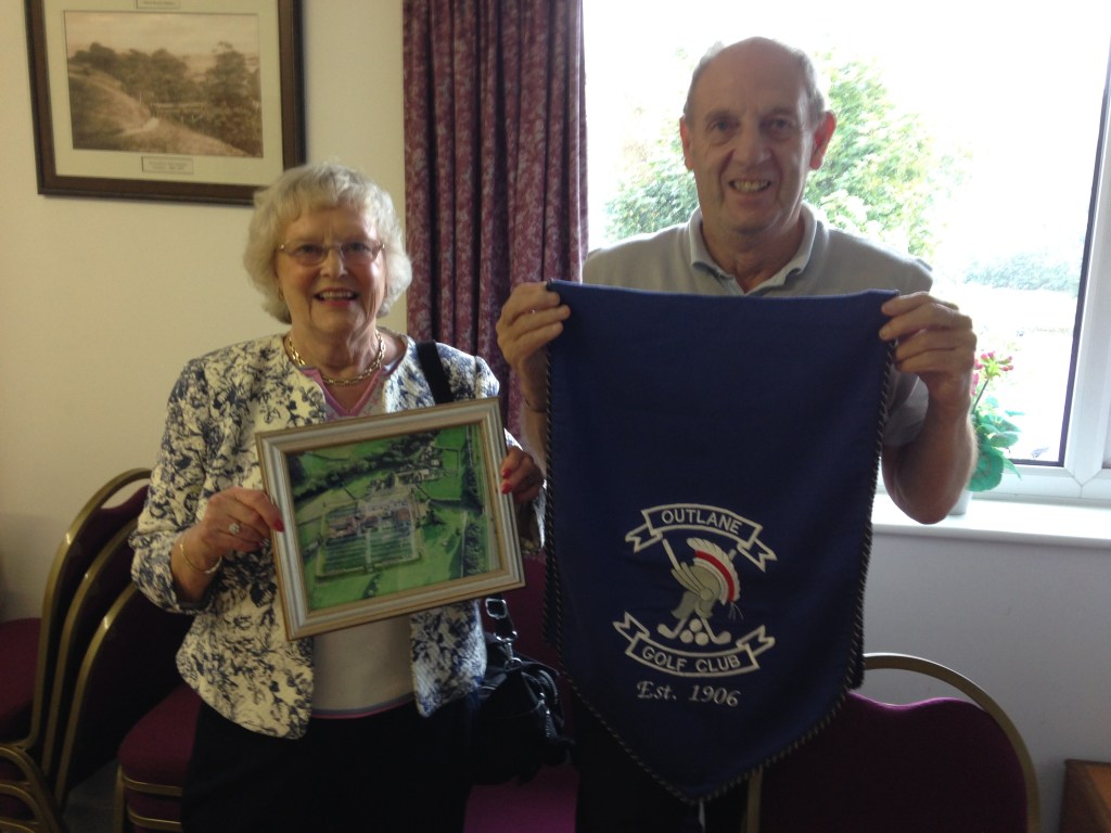
On a separate field trip in the spring of 2018 Benjamin Dunn met with Outlane Golf Club joint captains Bob and Brenda Hazelden, whose association with the club goes back over three decades. Upon being invited into their office within the premises, the Hazeldens proudly brought out an assortment of paraphernalia and newspaper cuttings connected with the sites mysterious past and their extensive tenure at the club.
Moving 25 miles to the north east of Slack, the village of Adel lies at an important crossroads on the East to West Roman Road between Eboracum (York) and Deva (Chester) eventually leading to Segentium (Caernarfon). More locally it is situated between Calcaria (Tadcaster) and Verbeia/Olicana (Ilkley) heading up into the Pennines and the Yorkshire Dales on the road Olenacum (Elslack), known locally as Burwen Castle.
The following paragraphs come from the Roman Road Research Association website and its analysis of Adel being a likely candidate for Cambodunum:
The first major issue is between Tadcaster and Manchester, recorded as 38 miles in the Itinerary but in reality is at least 55 Roman miles. The obvious explanation is that a stage is missing, and Richmond and Crawford proposed that this must be Camelodunum, known to be in the vicinity thanks to Ptolemy (Richmond & Crawford, 1949, p. 43). They suggested that because Cambodunum (location unknown) and the supposed following stage Camelodunum were so similar, a scribe could easily have assumed that the latter was a repetition, and leave it out. They further suggested that the distance to Manchester, xviii in the manuscript, should have read xxiii, another instance of an “x” being misread as a “v”. This placed Camelodunum firmly at Slack. Rivet & Smith took this a little further, and proposed that the distance which should have been next to Cambodunum was also omitted, so that the “m.p. xx” that should have been next to Camulodunum, became next to Cambodunum instead. In other words, rather than look for Cambodunum twenty miles from Tadcaster, we should be looking twenty miles from the fort at Slack, Huddersfield.
The main road (RR712) between York and Manchester has always been assumed to run through the centre of Leeds, and based upon a few stray finds and the supposed discovery of a Roman ford (Faull 1981 p.162), Leeds, and in particular the long destroyed earthwork at Wall Flats became the focus of attention for Cambodunum. Rivet misquoted Bede (Rivet & Smith 1979, p. 159) as placing “Cambodono in regione quae vocatur Loidis” in the region of Leeds to back up this claim, whereas Bede’s text actually reads
“Attamen in Capodono, ubi tunc etiam villa regia erat, fecit basilicam, quam postmodum pagani, a quibis Eduini rex occisus est, cum tota easem villa seccenderunt; pro qua reges posteroires fecere sibi villam in regione quae vocatur Loidis”
But in Campodonum, where there was then a royal township, he (Saint Paulinus) built a church which the pagans, by whom King Edwin was slain, afterwards burnt, together with all the place. Instead of this royal seat the later kings built themselves a township in the country called Loidis.
Bede, Historia Ecclesiastica, Book II, chapter XIV
Unfortunately for Leeds, it is only 18.6 Roman miles from Slack, and not the 20 miles stated by Rivet & Smith (Rivet & Smith 1979, p. 159) so it seems unlikely. It is important to note that whilst RR712 has been assumed to go through the centre of Leeds, the road has never actually been found over the near twenty eight miles from Thorner, where the road supposedly leaves RR29, to the area just north of Huddersfield, where it has recently been observed on lidar imagery (see RR712 in this gazetteer). Not only that, but no Roman site is known along that stretch. This passage pretty much rules out any chance of Cambodunum being Slack as has been claimed by many writers over the years, as there is no evidence or likelihood of there having been a “villa regia” at the windswept and inhospitable site of Slack, right on the southern edge of Elmet. However, there is another intriguing possibility. What if the road, or at least that followed by the itinerary, did not go through Leeds at all, but branched off the Ilkley to Tadcaster road (RR72b) at the known Roman settlement near Adel, north of Leeds, and that Adel is Cambodunum (Wilson, 2016 p.284 & Haken 2012)? Adel is 14.6 Roman miles from Tadcaster, and would be about 21.5 Roman miles from Slack along the likeliest route. This might at first seem a stretch, but actually there is more evidence for this theory than there is for the route through Leeds. Not only do we have a known settlement of clear local importance, in the right place, but there is also a double ditched feature just south of the Adel settlement which appears to be a Roman road heading SSW, not yet investigated (see RR72b in this gazetteer).
It is therefore suggested that this section of the original itinerary read.
The first major issue is between Tadcaster and Manchester, recorded as 38 miles in the Itinerary but in reality is at least 55 Roman miles. The obvious explanation is that a stage is missing, and Richmond and Crawford proposed that this must be Camelodunum, known to be in the vicinity thanks to Ptolemy (Richmond & Crawford, 1949, p. 43). They suggested that because Cambodunum (location unknown) and the supposed following stage Camelodunum were so similar, a scribe could easily have assumed that the latter was a repetition, and leave it out. They further suggested that the distance to Manchester, xviii in the manuscript, should have read xxiii, another instance of an “x” being misread as a “v”. This placed Camelodunum firmly at Slack. Rivet & Smith took this a little further, and proposed that the distance which should have been next to Cambodunum was also omitted, so that the “m.p. xx” that should have been next to Camulodunum, became next to Cambodunum instead. In other words, rather than look for Cambodunum twenty miles from Tadcaster, we should be looking twenty miles from the fort at Slack, Huddersfield.
The main road (RR712) between York and Manchester has always been assumed to run through the centre of Leeds, and based upon a few stray finds and the supposed discovery of a Roman ford (Faull 1981 p.162), Leeds, and in particular the long destroyed earthwork at Wall Flats became the focus of attention for Cambodunum. Rivet misquoted Bede (Rivet & Smith 1979, p. 159) as placing “Cambodono in regione quae vocatur Loidis” in the region of Leeds to back up this claim, whereas Bede’s text actually reads
Another suggestion is that Cambodunum was Leeds itself. There were earthworks recorded by Georgian era antiquarian Ralph Thoresby, recorded in his journal that
Supposed site of an unlocated Roman fort and centre of the 7th century Kingdom of Elmet possibly located somewhere in the vicinity of Leeds. The Roman name ‘Cambodunum,’ which is shown as ‘Camboduno’ in Antonine Itinerary and ‘Pampocalia’ in Ravenna Cosmography, can probably be attributed to an unlocated fort at Leeds, at the confluence of Sheepscar Beck with the Aire (SE 3033). Rivet’s identification of this name with the Leeds area is based on a translated extract from Bede’s ‘Historia Ecclesiastica’ II, 14 (Bede – 672-735 AD) which refers to “….. Campodonum (Campodono) where there was a royal dwelling, he (Paulinus) built a basilica (circa 627 AD) which some time afterwards the pagans, by whom King Edwin was killed, burnt, together with the whole dwelling. In its place later kings built a dwelling for themselves in the region which is called Leidis (Leeds) ….”. The kings referred to by Bede were those of the Kingdom of Elmet which retained its independence into the 7th century. The sense of ‘Cambodunum’ is ‘fort at the bend (of a river) or less probably ‘crooked fort’.

Leave a comment